

Alpin Quest PRO (Free paid)
v10.0.200+2500от NabzClan
0 Отзывы
ноя 16, 2026
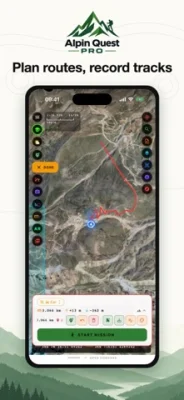
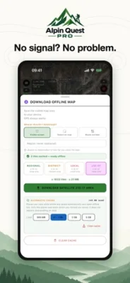
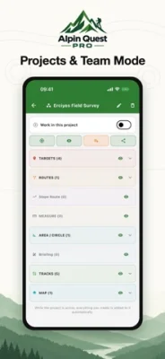
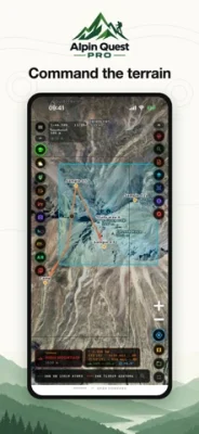
Последняя версия
Версия10.0.200+2500
Обновленоноябрь 16, 2026
РазработчикNabzClan
Категории
Utilities
Размер файла23.62 MB
Загрузки31
ЛицензияFree
ID пакетаcom.alpinquest.app
App Store Status
Needs Update
Sidelix v10.0.200+2500 • App Store v10.0.250+2600
Жалоба
Sign In to Report
Needs Update
Sidelix v10.0.200+2500
→
App Store v10.0.250+2600
0 requests
Private Community — Sign in to request v10.0.250+2600
Only signed-up members can submit update requests.
Private community — sign in with your member account to download.
Need Help Installing?
Ensure you have a valid signing certificate installed. If you're using AltStore, open this page in Safari and tap 'Install' to trigger the prompt.
Подробнее о Alpin Quest PRO (Free paid)
free paid app ----- Alpin Quest PRO is a professional GPS and field GIS application developed for military personnel, geologists, surveyors, foresters, mountaineers, hunters, and off-road drivers. Import paper maps to your device and track your precise location offline in the field.
MAPS
• Satellite, topographic, hybrid, and street maps; contour lines and shaded relief
• Named peaks, mountain passes, water sources, and rivers
• MGRS and UTM kilometer grids; scale lock capability (e.g., 1:25,000)
• Real-time terrain type, slope, and elevation data
IMPORT CUSTOM MAPS
• GeoPDF (ArcGIS, QGIS, stand maps), GeoTIFF, MBTiles, GeoPackage
• KMZ overlay layers and multi-level large KMZ archives
• Shapefile (ZIP), KML/KMZ vector files, Memory-Map (.qct), AlpineQuest AQX
• Image with world file: PNG, JPG, TIFF with PGW, JGW, TFW
• Collar clipping (hide white borders), transparency adjustment, and layer ordering
OFFLINE FUNCTIONALITY
• Download current screen view, selected map areas, or route corridors
• Automatic caching of visited locations
• Full functionality without cellular network coverage
COORDINATE SYSTEMS (19)
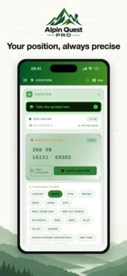
• MGRS, UTM, USNG, WGS84, DMS, DDM, Plus Code, QTH
• ED50, CK-42 / SK-42, BNG (OSGB), India Grid, NSF LCC, Lambert Maroc
• Gauss-Krüger Argentina, Arc 1960, RSO Malaya, SAD69
• Simultaneous coordinate display across all systems with one-tap copy
• Magnetic declination (NOAA WMM), true, magnetic, and grid north; degrees or mils
WAYPOINTS & TARGETS
• Unlimited waypoints, photo attachments, categories, and quick search
• Manual coordinate entry and waypoint averaging for maximum accuracy
• Live distance, bearing, and estimated time of arrival (ETA)
• Customizable label positions: top, bottom, left, right
ROUTES & TRACK RECORDING
• Point-to-point, freehand drawing, or finger-traced route creation
• Auto-routing optimized for walking, driving, and hiking
• Elevation profiles with real-time ascent and descent metrics
• Continuous background track recording with speed and distance statistics
• Off-route proximity alerts
3D TERRAIN
• Review routes and tactical areas overlaid on real 3D terrain elevation
AREAS & DRAWING
• Polygons, circles, and rectangles; precise area and perimeter calculations
• Map-based reshaping, vertex editing, and splitting
• Geology rock hatch patterns; freehand sketch and text annotations for briefings
PROJECTS (GIS) & TEAM MODE
• Consolidate waypoints, routes, areas, and custom maps into unified projects
• Export to KML, KMZ, GPX, Shapefile, and UTM Shapefile
• Team Mode: Share project data with team members and track team positions live
AR & WATCH INTEGRATION
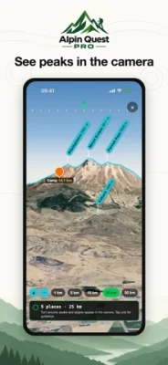
• Augmented Reality (AR) camera view identifying surrounding peaks and passes
• Apple Watch bearing guidance and compass navigation
FIELD TOOLS
• Proximity alarm: alerts when approaching target points
• Photo coordinate and direction stamping
• Weather forecasts: hourly and 7-day outlook, sun/moon phases and rise/set times
• Battery-optimized tracking profiles
• Volume button zoom control for gloved use
• Gridded PDF map export (A4, A3)
• Interactive walkthrough tutorial
FILE SHARING
• Import: GPX, KML, KMZ, GeoJSON, DXF, Shapefile
• Export: GPX, KML, KMZ, CSV, Shapefile, GeoPDF, GeoPackage
• Direct opening from WhatsApp, Mail, and the Files app
Privacy Policy: https://www.cte.militaryapp.net/2026/09/14/alpin-quest-pro-outdoor-gps/
Terms of Use (EULA): https://www.apple.com/legal/internet-services/itunes/dev/stdeula/
• Satellite, topographic, hybrid, and street maps; contour lines and shaded relief
• Named peaks, mountain passes, water sources, and rivers
• MGRS and UTM kilometer grids; scale lock capability (e.g., 1:25,000)
• Real-time terrain type, slope, and elevation data
IMPORT CUSTOM MAPS
• GeoPDF (ArcGIS, QGIS, stand maps), GeoTIFF, MBTiles, GeoPackage
• KMZ overlay layers and multi-level large KMZ archives
• Shapefile (ZIP), KML/KMZ vector files, Memory-Map (.qct), AlpineQuest AQX
• Image with world file: PNG, JPG, TIFF with PGW, JGW, TFW
• Collar clipping (hide white borders), transparency adjustment, and layer ordering
OFFLINE FUNCTIONALITY
• Download current screen view, selected map areas, or route corridors
• Automatic caching of visited locations
• Full functionality without cellular network coverage
COORDINATE SYSTEMS (19)
• MGRS, UTM, USNG, WGS84, DMS, DDM, Plus Code, QTH
• ED50, CK-42 / SK-42, BNG (OSGB), India Grid, NSF LCC, Lambert Maroc
• Gauss-Krüger Argentina, Arc 1960, RSO Malaya, SAD69
• Simultaneous coordinate display across all systems with one-tap copy
• Magnetic declination (NOAA WMM), true, magnetic, and grid north; degrees or mils
WAYPOINTS & TARGETS
• Unlimited waypoints, photo attachments, categories, and quick search
• Manual coordinate entry and waypoint averaging for maximum accuracy
• Live distance, bearing, and estimated time of arrival (ETA)
• Customizable label positions: top, bottom, left, right
ROUTES & TRACK RECORDING
• Point-to-point, freehand drawing, or finger-traced route creation
• Auto-routing optimized for walking, driving, and hiking
• Elevation profiles with real-time ascent and descent metrics
• Continuous background track recording with speed and distance statistics
• Off-route proximity alerts
3D TERRAIN
• Review routes and tactical areas overlaid on real 3D terrain elevation
AREAS & DRAWING
• Polygons, circles, and rectangles; precise area and perimeter calculations
• Map-based reshaping, vertex editing, and splitting
• Geology rock hatch patterns; freehand sketch and text annotations for briefings
PROJECTS (GIS) & TEAM MODE
• Consolidate waypoints, routes, areas, and custom maps into unified projects
• Export to KML, KMZ, GPX, Shapefile, and UTM Shapefile
• Team Mode: Share project data with team members and track team positions live
AR & WATCH INTEGRATION
• Augmented Reality (AR) camera view identifying surrounding peaks and passes
• Apple Watch bearing guidance and compass navigation
FIELD TOOLS
• Proximity alarm: alerts when approaching target points
• Photo coordinate and direction stamping
• Weather forecasts: hourly and 7-day outlook, sun/moon phases and rise/set times
• Battery-optimized tracking profiles
• Volume button zoom control for gloved use
• Gridded PDF map export (A4, A3)
• Interactive walkthrough tutorial
FILE SHARING
• Import: GPX, KML, KMZ, GeoJSON, DXF, Shapefile
• Export: GPX, KML, KMZ, CSV, Shapefile, GeoPDF, GeoPackage
• Direct opening from WhatsApp, Mail, and the Files app
Privacy Policy: https://www.cte.militaryapp.net/2026/09/14/alpin-quest-pro-outdoor-gps/
Terms of Use (EULA): https://www.apple.com/legal/internet-services/itunes/dev/stdeula/
Оценить приложение
Добавить комментарий и отзыв
Отзывы пользователей
На основе отзывов (0)
Отзывов пока нет.
Sign in with your NabzClan account to comment and rate. No account? Create one.
Ещё »

Популярные приложения

YouTube plusPoomSmart

Shadowrocket (Free paid)NabzClan
Minecraft (Free Paid)NabzClan

MovieBoxProNabzClan

Spotify - Eeveejaydenjcpy

Brain Test: Tricky Puzzles (Hacked)NabzClan
Alpin Quest PRO (Free paid)NabzClan
Sea Battle 2 (Tweaked)NabzClan

Roblox Deltadelta team

TerrariaNabzClan